
Kalpitiya Pilot area
It was identified during phase-I of DSWRPP2 that Groundwater aquifers have contaminated due to extensive usage of agrochemicals farming fields Therefore, it is supposed to establish automated monitoring system for the area to collect real-time data from good fields, which facilitate to monitor closely the impact relations on water quality and quantity with the external pressures in the area.
Main identified issues in the Peninsular are,
- Nitrate contamination in groundwater due to over application of fertilizer
- Hardness or Electrical Conductivity increasing in the dry season in some high agricultural areas
Prior to installing data logger, it was prepared two Nitrate distribution maps for wet and dry periods for the entire peninsular with using more sampling points (154 sample locations were obtained) due to complex hydrogeological settings of the area.
Based on the Nitrate distribution pattern and following factors, places where data loggers are to be installed, were selected.
- High Nitrate-contaminated areas in groundwater (places of exceeding 10mg/ of Nitrate-N )
- Areas that are in risk level due to Nitrate contamination (Places of having Nitrate levels between 5-10 mg/)
- Places where use carbonic fertilizer for the agriculture practices for their farming field
- Some good quality groundwater available places which can be taken as reference points
Following graphs shows the variation of Nitrate, Electrical Conductivity, Total Dissolved Solids and Water Level with time. These data obtained from a data logger that was installed at a high Nitrate-contaminated area in Mampuri area.
Kandakkuliya
Field observations near the data logger are as follow.
- Nearest lands are not having agricultural activities during last month (From February end to April-3rd week)
- Groundwater abstraction is low with respect to other seasons by means, not pumping for the agriculture activities
Therefore, Nitrate levels gradually become decreasing and then it shows almost constant value. However, initially it indicates about 130ppm Nitrate-NO3 and it has decreased up to 70ppm Nitrate-NO3. It may be occurred due to,
- Stop the agriculture during that time
- Due to decreasing the level pumping water in the area, groundwater movements can become over. Therefore, dissolving Nitrate component can be lower in groundwater
- Due to less groundwater movement, dissolved Nitrate contaminant may be concentrated in deeper level of the aquifer
- Not having considerable rainfall for the area
This also may be an effect for show lowering Nitrate concentration in Groundwater. Similarly, Electrical Conductivity (EC) value becomes high with time. Due to lack of rainfall and high evaporation may be caused for the increased of EC Values.
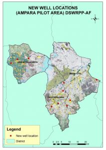
Ampara Pilot area
Under DSWRP-Additional Financing Project, activities of Ampara Pilot Area directed to the coastal belt of the District to identify sea water intrusion and three new areas to address CKD issue and groundwater chemistry. In this context, there was 06 number of Divisional Secretariats selected to study seawater intrusion and three number of DSDs were selected to study CKD issue in this region.
The following map is showing the extended areas of Ampara pilot area under the study of DSWRPP-AF. Initially, there was conducted a main awareness program to address the scope of the project activities to government officers in higher management in the year 2015. After that, there was three number of mini-awareness programs were conducted to the Dehiattakandiya, Mahaoya and Padiyathalawa DS Divisions to aware the scheduled special activities for the particular areas to address CKD issue.
In this regards, initially, it was collect the basic details of identified CKD patients in the area with the support of Grama Niladharis in DSDs. Basically, people who living in these areas were utilized shallow groundwater from constructed dug wells in the own land premise for drinking and another day to day activities. Still, these areas under developing status and there were not supplied basic needs such as good quality water, infrastructures, job facilities, etc. Except these, education levels of the community are very poor and based on that, they don’t have the potentiality to manage their basic conditions by existing sources.
After getting information of groundwater uses and their habitats, geophysical investigations were done for the construction of new deep wells to address deep-seated water quality and quantity. Figure I discuss the details of new good locations and figure 2 is illustrating the new well locations in the local map below.
Badulla Pilot area
The main objective of the study is Water Quality Assessment to establish the Ground water quality monitoring network in Badulla district.The sampling was performed on these selected points for the chemical analysis work to obtain the water chemistry spatially as well as temporally
Different types of water bodies such as tube wells, dug wells, streams, tanks, and irrigation channels were identified and information on those water bodies such as the technical data of wells, rock type, morphology and soil type at each location and the pollutants were collected during the field survey in Badulla districts.
High values of fluoride are identified in certain urbanized areas such as Badulla town and RidimaliyaddaThe fluoride is the one of the major issue identified in the pilot area from the analysis results. Most of the area of monitoring locations indicates high fluoride in groundwater.The Phosphate (PO4) values of deep groundwater near to the permissible level (2mg/l) at the locations of Mahiyanganaya, Ridimaliyadda, Kandakatiya and Migahakiwla.
Mahiyanganaya, Ridimaliyadda, Kandakatiya and Migahakiwla area basically dominated by paddy lands and farmers used various pesticides and weedicides for their cultivations. These pesticides may have a strong impact on the increase of PO4 in groundwater. PO4 directly impact to human health such as Urolithiasis (Urine stones), skeletal etc.
According to the results of water samples, deep aquifer groundwater is affected by F, especially in Badulla and Welimada areas.PO4 values are close to the permissible level in the study area. It is obvious that the groundwater is being contaminated in the area due to the impact of excessive applications of fertilizers.
Based on the information collected during the study and the input from the health authorities, a remarkable number of CKD patients have also been identified in these areas. So a program has been initiated to extend its project activities to extend to 4 DS divisions- Mahiyanganaya, Ridimaliyadda, Kandakatiya and Meegahakiwla- to identify the relationship between groundwater chemistry and CKDu.
Jaffna Pilot area
Initial water quality assessment has performed and finalized the long term monitoring points. Geophysics to be carried out to identify the seawater intrusion surveillance monitoring line with test boreholes along the interface line.Hardness distribution which is another dangerous issue in Anuradhapura, shows a slight increment in concentrations which is much more visible in areas around Medawachchiya. Further in the areas where the concentrations are high the pattern remains the same.
Anuradhapura Pilot area
Being the most critical issue in Anuradhapura district, Fluoride distribution shows the same variation with a slight decrement in concentrations which is much more visible in areas around Medawachchiya. Further in the areas where the concentrations are high the pattern remains the same.
Gampaha Pilot area
Objectives
- Industrial pollution
- Sea water intrusion
Outcomes
1. Low pH values were identified.
- No specific distribution pattern
- Low pH water results from the corrosion of pipes and no direct health problems
2. High NO3 levels in some specific locations
- A localized issue
- Due to sanitary problems
3. Water level fluctuation
- 08 number of data loggers have installed